

Products and services

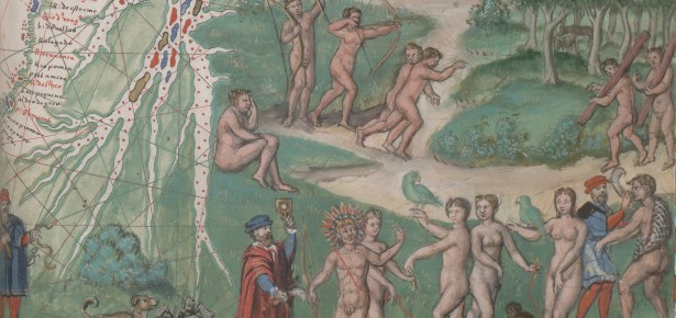
This book project grew out of a visual puzzle: where did the images of peoples of the Americas on late medieval and Renaissance European maps come from, what were they doing there, and why might they have mattered to the people devising and viewing them? Between my M.Phil. and Ph.D. research, I was a curator at the British Library Map Library. Here I noticed the rich variety of the cartographic archive for studying the impact of European exploration and colonialism on European visual culture, science, and thought: how travellers and thinkers made sense of observations and testimony about distant places, and the consequences for ideas about nature, the world, and people and other living things. Yet, when I began my PhD dissertation on images of New World peoples on European maps and the construction of ethnographic knowledge, almost nobody thought I had a real project: images of Brazilian cannibals, Patagonian giants, and other peoples were dismissed by map specialists as ‘mere decoration’; for art historians, these images were neither innovative nor especially beautiful or technically skilled, and they certainly were not canonical; in the late 2000s, few historians attended properly to visual archives as evidence in their own right; even historians of science did not (and still generally do not) consider illustrations on maps as part of an archive of scientific imagery and practice. What was clear to me, however, was that we couldn’t know these maps – complex geographic diagrams often full of writing as well as images – meant without doing the work. In other words, rather than simply assuming that an archive of 2,000 Renaissance maps and atlases containing distinctive imagery and textual descriptions of peoples of the Americas had nothing interesting to tell us, I was going to analyze it.
This voyage of adventure involved physical and mental gymnastics, and more than a little diplomacy and chutzpah to get permission to see unique, fragile, sometimes awkwardly-shaped artefacts. Analyzing giant maps involved adopting multiple body positions. In the Bibliothèque Nationale de France, several Dutch wall maps hang, in the manner of theatre backcloths, at the back of a basement called le théâtre. To consult them, I climbed a ladder with a very hot lamp; when I smelled burning, I hoped it was my hair. Diogo Ribeiro’s 1529 framed manuscript world map in the Vatican Library was almost immovable, interred in a basement from which its size prevented its escape, and had to be consulted in its caged vault.
The results of this work became Renaissance Ethnography and the Invention of the Human: New Worlds, Maps and Monsters. This book reveals how illustrated maps produced in western Europe c.1450-1650 constituted new forms of knowledge about distant peoples. By analyzing manuscript and printed maps alongside prints, natural histories, geographies, costume books, and travel writing, I argued that new mapping techniques made the idea of monstrous peoples deformed by nature central to the category of ‘human’. In an age when scholars, missionaries, native peoples, and colonial officials debated whether peoples of the Americas could – or should – be converted or enslaved, maps were uniquely suited for assessing the impact of environment on bodies and temperaments. By revealing that map illustrations of headless men, giants, and cannibals, as well as images of cities and everyday life, were scientific diagrams rather than fantasies, this book showed the centrality of spatial thinking for early modern science, and urged an expansion of the sources via which scholars study the prehistory of race.
Art and science in pre-modern Europe were not separate arenas, but rather were artisanal and theoretical variants of modes of engaging with the natural world. My book speaks to the potential of work that listens to its sources not just for what ‘facts’ they reveal but also for what they suggest about the best methods by which to study them and the questions that might generate the most illuminating answers, conversations, and further questions. The early modern period was a pre-disciplinary era: there is no reason why academic disciplines that were devised later, in the nineteenth-century, should map tidily onto how the past unfolded, or onto particular types of artefact. Maps comprise a hybrid genre that integrates text, image, and diagram. By examining sources that straddle current disciplines, we can better understand past modes of thought.
The typical visual metaphor for interdisciplinarity is the Venn diagram: where the edges of one discipline meet those of another, interdisciplinary work resides. A better metaphor is that of the space-time portal: good interdisciplinary work generates a portal from the centre of one discipline to the centre of the next, and the next, sewing them together with such questions as: how have the boundaries of the idea of the ‘human’ changed over time?
Thus my book integrates histories of science, art, the Americas, and Europe, inhabiting an emerging historiography cutting across fields to shed new light on pressing questions of race, empire and identity. Depictions of monstrosity on maps were neither simple decorations nor fabrications but rather carefully thought out, diagrammatic renditions of empirical observations or of accounts purporting to contain them. Images are documents in their own right that offer independent evidence and counter-evidence.
The questions that continue to animate my work uncover the re-configuring and transmission of ideas in the first global age. Writing Renaissance Ethnography and the Invention of the Human led me to consider broader questions about imagery and the relevance for scientists, policy makers, and journalists of understanding how visual literacy, visual bias, and popular perceptions of expert authority have changed over time. Moreover, the cognitive connections between art and science in early modern Europe offer a rich legacy to inspire creative, innovative scientific thinking today.

Surekha Davies is a historian of art, science and ideas whose research focuses on visual and material practices of making natural knowledge in the early modern world, c.1400-1800. ...
View profile >Keep up with the latest from Cambridge University Press on our social media accounts.


Latest Comments
Have your say!